

This companion provides additional technical context for readers seeking more background beyond the Investor & Partner Brief.
Overview of Existing Conjunction Management Processes
The U.S. Air Force’s Space Surveillance Network (SSN), conceived in the late 1950s and 1960s, was built for an era with only a few dozen objects in orbit. This ground-based optical and radar system—and the processes built around it – still underpin global space safety management.
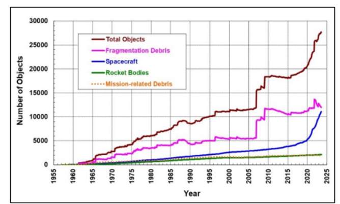
Image.[1]
Today, the Space Force’s Combined Space Operations Center (CSpOC) manages the SSN, with the 18th and 19th Space Defense Squadrons (SDS) responsible for turning sensor data into orbital state vectors.[2]
Data is distributed in two main forms:
- Two-Line Elements (TLEs): low-fidelity orbital data generated with General Perturbations methods, publicly available via space-track.org.
- Special Perturbations (SP): higher-fidelity vectors in the High Accuracy Catalog (HAC), though still carrying significant positional uncertainty expressed as a covariance volume.
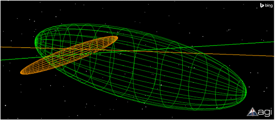
CSpOC performs daily pairwise checks across the catalog, flagging overlapping covariance volumes as potential conjunctions. These yield a probability of collision (PoC), time of closest approach (TCA), and predicted miss distance. Warnings are distributed to operators as Conjunction Data Messages (CDMs).
While this process appears comprehensive, 2025 operator interviews reveal a system plagued by uncertainty and manual workflows:
“It’s not like… they say we’re 50m away and we say we’re 51m away… it’s they say we’re 3km away and we say we’re 50m away.” [Discussion about why operators manually manage CDMs]
“Our current operating strategy is if a bad conjunction arises, drop everything and try to miss it by a mile… [it’s] quite disruptive to operations.”
This is not theoretical critique but the operational reality for spacecraft owners making high-stakes decisions on unreliable data.
The system’s limits are structural. From tracking dozens of objects at inception, the HAC now tracks ~31,000 objects (~13,000 active spacecraft). Projections point to 60,000–100,000 active spacecraft by 2030, which could translate to as many as 150,000–300,000 total tracked objects, far beyond the design assumptions of covariance-based traffic management.
Most U.S. civil and commercial operators rely on space-track.org data pipelines, often supplemented with internally built tools. Defense operations rely on similar processes. To bridge gaps, many operators purchase services from commercial space situational awareness (SSA) providers. Interviews have revealed the primary reasons such services are procured:
- lack of internal expertise,
- reducing operational load,
- access to supplementary sensors/algorithms,
- as an ‘insurance policy’ against catastrophic events, or
- to signal diligence to customers.
These commercial providers almost exclusively still rely on ground-sourced data as well. Some simply add analytics or white-glove support to the existing Space Force provided data, others have installed their own additional ground-based observatories, generally optical or radar, and use that supplemental data to add accuracy, higher revisit rates, etc.
Meanwhile, space-sourced sensing remains broadly underutilized, generally applied only in narrow mission-specific contexts. While some star tracker manufacturers have enabled space object monitoring features, implementations remain largely academic. Yet competitors recognize its latent value: one SSA company noted, ‘We would buy star-tracker RSO monitoring data today if it were available.’
Demand signals for space-based monitoring have never been stronger for the U.S. government, with unprecedented spending allocated towards the Golden Dome in today’s contested environment. Defense operators, in particular, will benefit from system-level implementation and on-demand data to maintain operational superiority and preserve resilient, assured access to space.
Unexpected Costs of Maneuvering & Space-Based Sensing
Compared to most operators that manage Conjunction Data Messages (CDMs) through manual, ground-based systems, SpaceX Starlink’s autonomous onboard collision avoidance system is often considered state of the art. Ironically, its guiding philosophy—’when in doubt, maneuver’—has introduced a new source of uncertainty into the space environment.
SpaceX’s evolving strategy, documented by Professor Hugh Lewis (University of Southampton), illustrates how reliance on maneuvering as the primary safety mechanism escalates risks when based on uncertain data. In just six months ending May 2025, Starlink performed 144,404 collision avoidance maneuvers—an exponential increase, despite the constellation growing only linearly.[3]
| Starlink Avoidance Maneuver Threshold, based on Probability of Collision (PoC) | Conservatism increase from industry baseline | |
| Early 2024 | PoC 1×10⁻⁵ (1 in 100,000) | 10x |
| Mid 2024 | PoC 1×10⁻⁶ (1 in 1,000,000) | 100x |
| Late 2024 – Early 2025 | PoC 3×10⁻⁷ (3 in 10,000,000) | 333x |
| Industry baseline maneuver threshold, PoC = 1×10⁻⁴ (1 in 10,000) | ||
Within two years, SpaceX increased maneuver conservatism from industry baseline by a factor of ~300x, drastically increasing the number of maneuvers per satellite. Lewis concludes that this shift reflects “an attempt to maintain the same level of safety… For some reason, it is harder now (or will be) to maintain the safety of the Starlink satellites than it was before.” (Lewis)[4][5]
Additional research (Lewis) shows that constellations face residual cumulative risk: with thousands of satellites, the probability of collision can approach 1 in 10 (Lewis).[6] This raises the risk not only of Kessler Syndrome, where a single collision cascades into widespread orbital debris, but also of a subtler feedback loop: more maneuvers → greater positional uncertainty → more maneuvers.
Post-maneuver uncertainty is significant: positional errors can increase up to 1,000× immediately after a maneuver, persisting for days.[7] This effect holds whether maneuvers are cooperative (planned and reported) or uncooperative (unreported or misreported).
A stark historical example is the 2009 Iridium-Cosmos collision. Despite monitoring by the SSN and JSpOC, Iridium 33 executed two small, unreported station-keeping maneuvers just 10 hours before colliding with the defunct Cosmos 2251. Post-mortem analysis by COMSPOC found that these maneuvers increased collision probability by an estimated ~40 orders of magnitude—a staggering increase, contributing directly to the collision. The collision produced ~1,800 cataloged debris objects >10 cm, ~800 of which remain in orbit as of 2025, still threatening national security and commercial operations.[7]
The lesson is clear: maneuvering carries systemic costs. Safer operations require not just better maneuver policies, but higher-fidelity input data and more integrated systems for sharing it.
A growing body of research demonstrates that space-based sensing consistently outperforms ground-only systems:
- A recent study of space and ground sourced observational data found that “tracking accuracy in Space-Based Space Surveillance (SBSS) scenarios is highest across all evaluated data fusion methodologies… and SBSS+GBSS integration surpasses GBSS alone.”[8]
- Canada’s NEOSSat microsatellite study showed spacecraft could dramatically improve their own safety:
- 96% of conjunctions were self-observable from space.
- In-track positioning error improved by a factor of two or more when using space-based observations.[9]
The findings here represent only a brief sample of the broader body of research, but across the field the conclusion is consistent: multi-domain, multi-phenomenology observation data is essential to deliver the reliability and resilience operators demand. Solutions that unlock this advantage will define the next generation of space safety and competitiveness.
[1] NASA. (2024). Cost and Benefit Analysis of Mitigating, Tracking, and Remediating Orbital Debris. NASA, Office of Technology, Policy, and Strategy (May 2024), ii Figure ES1.
[2] 18th & 19th Space Defense Squadron (Ed.). (2023). SPACEFLIGHT SAFETY HANDBOOK FOR SATELLITE OPERATORS (1.7). Combined Force Space Component Command Vandenberg Space Force Base, California, USA.
[3] Lewis, Hugh. (2025, July 2). Starlink Manoeuvre Update July 2025. LinkedIn Articles.
[4] Lewis, Hugh. (2025, July 2). Starlink Manoeuvre Update July 2025. LinkedIn Articles.
[5] Lewis, Hugh. (2025, July 22) “SpaceX Quietly Changed its Approach to Space Safety.” LinkedIn Articles.
[6] Ibid.
[7] Oltrogge, D. (2024). Deep operator and SSA collaboration for space sustainability. Science Direct, 11(2).
[8] Hussain, K., Safwat, N.E., Thangavel, K., Sabatini, R. “Space-based debris trajectory estimation using vision sensors and track-based data fusion techniques.” Acta Astronautica, January 2025.
[9] CSA & Defence R&D Canada Ottawa. (2019). On-Orbit Observations of Conjuncting Space Objects Prior to the Time of Closest Approach. Amos Tech, 2019(Advanced Maui Optical and Space Surveillance Technologies Conference (AMOS)), 7. Amos.